A typical time building flight:
It’s nearly noon, our cruising altitude is 5,500ft. We have been tracking Victor Airway 3 for a few hours on our way to Key West. Our magnetic heading is currently 155°, with a 10° wind correction angle due to the summer sea breeze off of the Atlantic Ocean. The navigation log you created based on the forecast winds has been fairly accurate as we were only 3 minutes off our leg time over the Melbourne VOR. Currently we are in contact with West Palm Beach Approach. Ahead of us lay Miami, and then Homestead General Airport, our refueling point. We have been monitoring the weather development along our path. As the day has been warming up, and the sea breeze pushes in moisture inland towards the west, the clouds have started to develop in height. Miami ATIS is still too far away for us to get an accurate picture of the cloud bases over the radio. But it is clear that they are starting to develop into columns of moisture. Not quite yet Towering Cumulous, but it certainly won’t take long before we might have to circumnavigate the localized rain showers that will start springing up on this mid-June day.
As the traffic over West Palm Beach Approach is currently at a lull, you ask ATC for permission to leave the frequency. ATC advises you to cross directly over the West Palm Beach International Airport, and then to fly a 180° heading upon passing over head. We are to report back onto frequency within 5 minutes. You have already tuned in Flight Watch on the standby frequency a head of time to safe time while off frequency. “Flight Watch this is Skyhawk 20571…” You report your position and the destination of Homestead General and request an in-flight weather advisory. Flight Watch advises you of some moderate to heavy precipitation based on radar imagery. This weather is still well west of us. However, the cloud bases are starting to get lower than expected during our morning weather forecast. We thank Flight Watch for the help and decide that we will continue to monitor the situation as we continue. As of yet the cloud bases are reported as 2000ft scattered towards the west. Along the shoreline there are just a few fair weather cumulous moving inland. We report back up on the West Palm Beach frequency just as we are about to cross over the airport. “Roger, Skyhawk 20571” is the reply we receive.
West Palm Beach Approach hands us off to Miami Approach Control. We had planned to overfly Miami International Airport navigating by using the Miami VOR, but Miami isn’t allowing this due to the arrivals into that airport. We are given the option to fly east of Miami over the shoreline, or west over the Everglades. Both options will take about the same time to navigate around the busy Miami Class Bravo airspace. And we determine that we have plenty of fuel taking either off rout option. If we decide to fly over the everglades, the cloud bases will keep us below 1,500 ft. If we follow the shoreline we will have to stay below 1,000ft. Both options will keep us low and clear of clouds. To us, going east and flying low over Miami Beach sounds more appealing. Low over the Everglades, our options are limited in the event in the unlikely event of an engine failure, especially with all the alligators. We elect to fly along the shoreline over the sharks instead. “Skyhawk 20571, fly heading 150°, intercept the shoreline southbound, descend and maintain at or below 1,000ft. Be aware of numerous targets along the shoreline.”
The water has gradually been getting a more tropical blue tinge as we continue south. Almost three hours into the flight we are cleared direct to Homestead. “Skyhawk 20571, squawk VFR, frequency change approved.” We are now outside of Miami’s airspace, it is up to us to navigate without assistance to Homestead. This includes avoiding the airspace of two Class Delta airports between us and our destination. Using the GPS we enter the Homestead General Airport’s identifier and select the direct function on the GPS. The GPS informs us that our new direct track is a 253° heading to the airport. The track should keep us clear of the airspace ahead, but we remain careful to keep clear of it as the corridor between us and Homestead is rather narrow. We easily spot the large transmission tower that lies between us and our destination. As the tower is higher than our altitude we decide to fly around the right hand side of it, this gives us more clearance of the surrounding airspace. Just beyond the tower is Homestead General Airport, a small two runway, uncontrolled airport. It takes you a while to spot the airfield as you compare the surroundings to your aviation sectional map. Eventually you are able to spot the airport and rush to tune in the CTAF frequency. Admittedly you should have tuned in the frequency and listened to the weather recording earlier. You decide to stay clear of the airport area as you gain a better understanding of the wind conditions and traffic pattern. Next time you resolve to be better prepared for your destination to not allow yourself to get rushed like this.
The traffic pattern is busy today. Skydivers are falling from the sky at the south end of the airport. Sailplanes are being launched from the grassy area to the left and parallel of runway 9 and there are plenty of students in the traffic pattern practicing take offs and landings. You determine that the wind and traffic pattern is favoring runway 9, which has a standard left hand traffic pattern, as you are maneuvering to enter the pattern. Even with heavy traffic in the pattern you are able to seamlessly enter a mid-field downwind. We have to extend our downwind slightly as the traffic in front of us is on a long final, but eventually we are able to turn in behind him. “Homestead traffic, Skyhawk 20571 is turning on a long final, runway 9, Homestead.” You make this traffic call out to make sure the student pilot behind us on downwind realizes we are on a long final, just in case he decides to turn onto his base leg early, inadvertently cutting us off. And to kindly bring to attention of the student in front of us that his final leg in the pattern is unusually long. We also mention that we are a full stop landing so the pilot behind us can create the necessary space between his aircraft and ours. Your final approach is nice and stable, you are correcting for a slight cross wind and we are merrily waiting for the aircraft in front of us to clear the runway or perform a touch and go. As he is landing longer than we expect we prepare ourselves for a go-around in case we must make one. Luckily as we get closer to the threshold the aircraft is not an issue and we are able to land. Your landing is nice and smooth and the longitudinal axis perfectly aligned with the centerline of the runway. Although it was a beautiful landing, you remark that you feel you floated slightly long and that you therefore missed your touchdown mark. I remind you that your landings have improved dramatically since we started flying together and that you will soon be able to consistently plant your wheels at any point specified on the runway with little fuss.
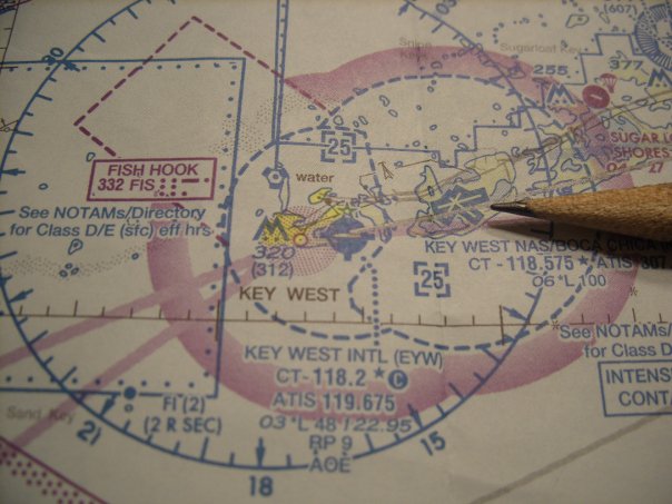
We taxi to the Roberts Air South FBO where we are greeted like family by the husband and wife owners. Here we will stretch our legs, enjoy some complimentary coffee and perhaps a pastry before we refuel for the last leg of our trip. We have travelled approximately 250 miles so far. Only 100 miles left to go before we touch down in Key West for some much needed relaxation!